A Trekker's Paradise in the Western Ghats
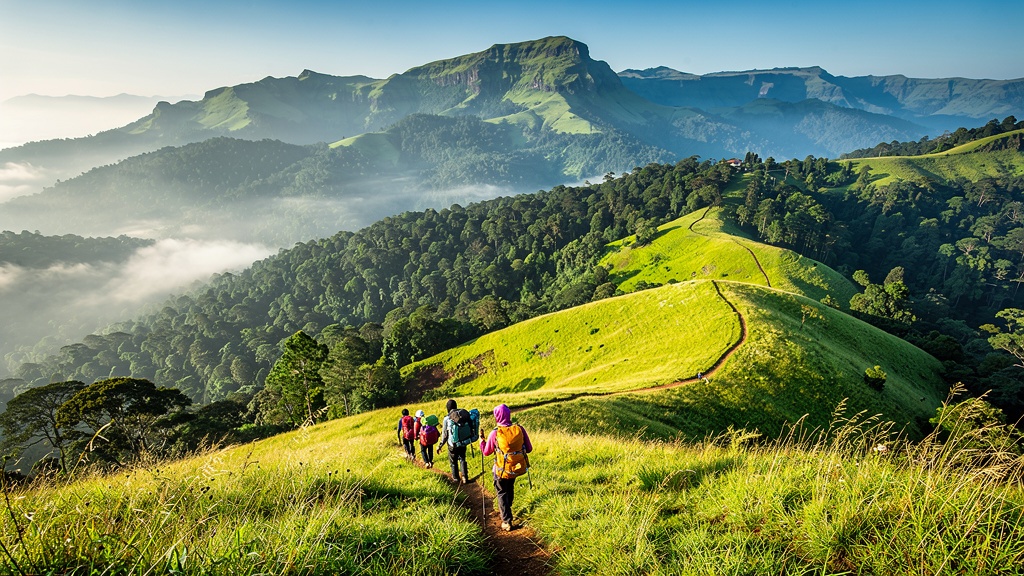
Chikkamagaluru is blessed with some of the most diverse and scenic trekking terrain in the country. The region's location in the Western Ghats — a UNESCO World Heritage Site and one of the eight most biodiverse hotspots on Earth — means that every trail offers not just spectacular views, but also an intimate encounter with an extraordinary range of flora and fauna. The shola forests, grasslands, coffee plantations, and rocky peaks create a patchwork of landscapes that change with every step.
Trekking in Chikkamagaluru is more than just a physical activity; it is a way to connect with the land and its stories. As you walk through the misty hills, you will pass ancient coffee plants that trace their lineage back to the seven beans planted by Baba Budan, cross streams that have been flowing for millennia, and stand on peaks that have witnessed the rise and fall of dynasties. The trails of Chikkamagaluru are paths through time itself, and every trek is a journey of discovery.
Whether you are a seasoned trekker looking for a challenging climb or a beginner seeking a gentle introduction to hiking in the Western Ghats, Chikkamagaluru has something for you. In this guide, we cover the best trekking trails in the region, with detailed information about difficulty levels, distances, best times to visit, and essential tips to ensure a safe and enjoyable experience.
Mullayanagiri Trek — The Ultimate Summit
The Mullayanagiri trek is the most popular and iconic trek in Chikkamagaluru, and for good reason. Standing at 1,930 metres (6,330 feet), Mullayanagiri is the highest peak in Karnataka, and the trek to its summit offers a thrilling blend of physical challenge and breathtaking beauty. The trail begins at Sarpadari, a parking area located about 20 kilometres from Chikkamagaluru town, and winds its way through grassy slopes, rocky outcrops, and patches of shola forest.
The trek is moderately challenging, with some steep sections that require careful footing, especially when the grass is wet. The total distance from the base to the summit is approximately 4 kilometres, and the ascent takes about 2 to 3 hours depending on your pace. As you climb, the views become progressively more spectacular, with the valleys and hills of the Western Ghats unfolding before you. On a clear day, you can see as far as the Kudremukh range and, some say, even the Arabian Sea in the distance.
The summit of Mullayanagiri is a flat area with a small shrine dedicated to Lord Mullayappaswamy and a police station — believed to be the highest police station in Karnataka. Watching the sunrise from the summit is an unforgettable experience, as the first rays of light paint the misty valleys in shades of gold, orange, and pink. The descent takes about 1.5 to 2 hours and is easier on the knees. The best time for the Mullayanagiri trek is from October to February, when the weather is cool and the skies are clear.
Trek Details: Distance — 8 km (round trip) | Duration — 3–5 hours | Difficulty — Moderate | Elevation Gain — 400 m | Best Time — October to February | Start Point — Sarpadari
Kudremukh Trek — The Horse Face Peak
Kudremukh, which translates to "horse face" in Kannada, is a stunning peak located about 100 kilometres from Chikkamagaluru town. The peak gets its name from its distinctive shape, which resembles the face of a horse when viewed from a certain angle. At 1,894 metres (6,214 feet), Kudremukh is the third-highest peak in Karnataka and offers one of the most scenic and rewarding treks in the Western Ghats.
The Kudremukh trek is considerably longer and more challenging than the Mullayanagiri trek, covering a distance of about 22 kilometres (round trip) with an elevation gain of approximately 650 metres. The trail passes through lush shola forests, vast grasslands, and numerous streams, offering a constantly changing landscape. The biodiversity along the trail is extraordinary, with opportunities to spot wildlife such as sambar deer, wild boars, langurs, and a wide variety of birds, including the Malabar trogon, Nilgiri wood pigeon, and great hornbill.
The trek takes approximately 8 to 10 hours to complete, and it is recommended to start early in the morning (around 6:00 AM) to avoid the afternoon heat and to allow enough time to reach the summit and return before dark. The summit offers panoramic views of the surrounding hills and valleys, and on clear days, you can see the Arabian Sea shimmering in the distance. The best time for the Kudremukh trek is from October to February. The trail can be very slippery during and immediately after the monsoon, so caution is advised.
Please note that the Kudremukh trek requires prior permission from the Karnataka Forest Department, as the area falls within the Kudremukh National Park. It is advisable to book through a registered trekking operator or your homestay host, who can assist with the necessary permits and arrange for a local guide.
Trek Details: Distance — 22 km (round trip) | Duration — 8–10 hours | Difficulty — Challenging | Elevation Gain — 650 m | Best Time — October to February | Permits — Required (Forest Department)
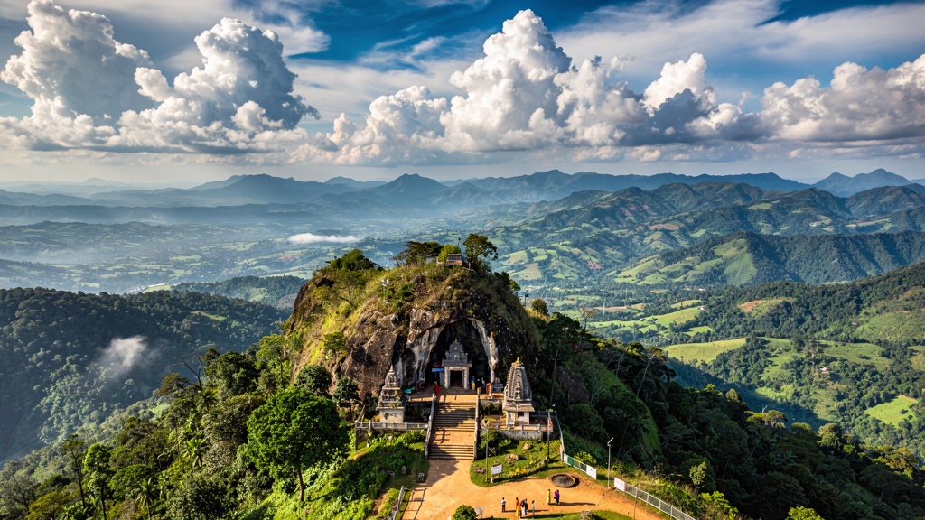
Baba Budangiri Trek — A Sacred Ascent
The Baba Budangiri trek offers a unique combination of natural beauty and spiritual significance. The trail leads to the Dattatreya Peetha, a cave shrine at an elevation of 1,895 metres that is revered by both Hindus and Muslims. The trek is shorter and less strenuous than the Mullayanagiri or Kudremukh treks, making it accessible to beginners and families.
The trek begins at the Manikyadhara Falls parking area and follows a well-defined trail through coffee plantations and shola forest patches. The walk is scenic throughout, with views of the surrounding hills and valleys opening up as you gain elevation. The shrine at the summit is a simple cave with a small entrance, and the atmosphere is one of deep peace and spirituality. The Manikyadhara Falls, located on the slopes of Baba Budangiri, is a seasonal waterfall that is particularly spectacular during the monsoon and post-monsoon months.
The total trekking distance is about 4 kilometres (round trip), and the entire experience can be completed in 2 to 3 hours, including time spent at the summit. The best time for the Baba Budangiri trek is from October to March, when the weather is pleasant and the views are at their best.
Trek Details: Distance — 4 km (round trip) | Duration — 2–3 hours | Difficulty — Easy to Moderate | Elevation Gain — 250 m | Best Time — October to March | Start Point — Manikyadhara parking
Kemmannugundi Trails — Gentle Walks & Nature Hikes
Kemmannugundi, the "Queen of Hills," is an excellent base for gentle nature walks and moderate treks. The area around the hill station is crisscrossed with trails that wind through coffee plantations, shola forests, and grasslands. The Raj Bhavan, Zindal Palace ruins, and the Rani Jhari viewpoint are all accessible via short, easy walks from the Kemmannugundi Guest House.
For a more adventurous hike, the trek from Kemmannugundi to Hebbe Falls is a popular choice. The trail is about 5 kilometres one way and takes you through coffee estates and dense forest before reaching the spectacular Hebbe Falls. The sound of the waterfall grows louder as you approach, and the sight of water cascading down from a height of 168 metres is awe-inspiring. The trail is moderately challenging, with some steep sections, and takes about 2 to 3 hours to complete one way.
Kemmannugundi is also the starting point for the trek to Kallathigiri Falls, a shorter and easier walk that is suitable for all age groups. The area is particularly beautiful during the monsoon and post-monsoon months when the vegetation is lush and the waterfalls are in full flow. The best time for treks around Kemmannugundi is from September to May.
Key Trails: Hebbe Falls Trek — 10 km (round trip), Moderate, 4–5 hours | Kallathigiri Falls — 2 km (round trip), Easy, 1 hour | Raj Bhavan Walk — 1 km, Easy, 30 minutes
Essential Trekking Tips for Chikkamagaluru
Trekking in the Western Ghats is a rewarding experience, but it also requires careful preparation and respect for the natural environment. Here are some essential tips to ensure a safe and enjoyable trekking experience in Chikkamagaluru:
- Start Early: Begin your trek as early as possible, ideally by 6:00 AM. This allows you to avoid the afternoon heat, gives you ample time to complete the trek before sunset, and offers the best lighting for photography. Sunrise from the summit is an experience not to be missed.
- Carry Sufficient Water: The humidity and physical exertion can lead to rapid dehydration. Carry at least 2 to 3 litres of water per person for a full-day trek. Reusable water bottles are recommended to reduce plastic waste.
- Wear the Right Footwear: Sturdy, comfortable hiking shoes with good grip are essential. The trails can be rocky, muddy, or slippery, especially after rain. Avoid flat-soled shoes or sandals.
- Dress Appropriately: Wear lightweight, breathable clothing that covers your arms and legs to protect against sunburn, insect bites, and thorny vegetation. Carry a light jacket or fleece as the temperature can drop significantly at higher elevations, especially in the early morning.
- Hire a Local Guide: For unfamiliar trails, especially long and challenging ones like Kudremukh, hiring a local guide is highly recommended. A guide ensures your safety, helps you navigate the trail, and enriches your experience with knowledge about the local flora, fauna, and history.
- Pack Essentials: In addition to water and snacks, carry a first-aid kit, sunscreen, insect repellent, a hat, a raincoat or poncho (during monsoon), a headlamp or torch (in case you are delayed), a fully charged mobile phone, and a power bank.
- Leave No Trace: Carry a trash bag and bring back all your waste. Do not litter on the trails. Respect the natural environment and avoid disturbing wildlife.
- Check Weather Conditions: Always check the weather forecast before heading out. Avoid trekking during heavy rain, thunderstorms, or dense fog, as trails can become dangerous. The monsoon season (June to September) is best avoided for challenging treks.
- Inform Someone: Let your homestay host or a friend know about your trekking plans, including your expected return time. This is especially important for solo trekkers.
Trekking Seasons in Chikkamagaluru
The best time for trekking in Chikkamagaluru is from October to February, when the weather is cool, the skies are clear, and the trails are in good condition. During this period, daytime temperatures range from 18°C to 25°C, making for comfortable trekking conditions. The post-monsoon months of October and November are particularly beautiful, as the landscape is still lush and green from the rains, and the waterfalls are flowing strongly.
The monsoon season (June to September) is not ideal for trekking, as the trails become slippery and leeches are abundant. However, for experienced trekkers who enjoy the challenge of trekking in wet conditions and want to experience the Western Ghats at their most lush and dramatic, the monsoon offers a unique and rewarding experience. Just be prepared for rain, mud, and leeches!
The summer months (March to May) are suitable for early morning treks, as the heat can be intense by midday. The trails are dry, and the views are clear, but the landscape is less green compared to the monsoon and winter months.
Responsible Trekking in the Western Ghats
The Western Ghats are an ecologically sensitive region, and it is our collective responsibility to ensure that our presence does not harm the environment. As a trekker, you can contribute to the conservation of this precious ecosystem by following these principles:
- Stay on marked trails to avoid damaging fragile vegetation and causing soil erosion.
- Do not pick flowers, plants, or fruits — leave them for wildlife and other trekkers to enjoy.
- Do not feed or approach wild animals. Observe them from a safe distance.
- Avoid making loud noises that disturb wildlife and other trekkers.
- Carry reusable water bottles and avoid single-use plastics.
- Support local communities by hiring local guides and buying from local shops.
- If you smoke, dispose of cigarette butts responsibly — they are a major fire hazard in dry grasslands.
By following these simple guidelines, you can help preserve the beauty and biodiversity of the Western Ghats for generations to come. Trekking in Chikkamagaluru is not just about conquering peaks; it is about forming a deeper connection with nature and becoming a steward of the environment.